Showing posts with label wildlife. Show all posts

Thursday, July 8, 2021

Cumberland Island


Located just north of the Georgia-Florida border, Cumberland Island National Seashore is a 17-mile-long barrier island. Although various people and cultures have made the island home, today access is highly regulated to protect its fragile ecosystems. No more than 300 visitors are allowed on the island at a time and the only way to visit is by boat. The number of vehicles is low and the lone hotel, which is extremely exclusive, is a holdover from decades past.

The National Park Service runs a 30-minute ferry to and from Cumberland Island. Spaces on the boat, which also ferries bikes and camping equipment for visitors, are limited and reservations are a necessity during peak times. Even in mid-May, before schools were out, the boat was quite full. An interesting assortment of people on the boat, in varying degrees of preparedness, were on our outward journey. A couple from the Air Force, coincidentally he was from the Louisville area as well, were taking the ferry for a four-day backpacking trip on the island to explore the northern half and enjoy some beach time. Their trip contrasted with two young women in short bright yellow jumper and sandals looking like she was out for an evening at the beach bars, seemingly unprepared for the sun, lack of services, and heat while on the island. I overheard her say that she was “really hungover,” which usually means dehydration. I thought to myself her day might not go well, although I could be wrong. I was a little surprised by the number of people who took the ferry across, unload equipment and carted it across the approximately one-mile width of the island to spend a day at the beach; admittedly the seashore is quite secluded, beautiful, and not at all busy.

Arriving shortly before 10am and having six hours to wander and explore, to see animals, and observe humans is a real luxury – the luxury of time. The only deadline is the departure time for the return ferry.

The St. Marys River is the dividing border between Florida and Georgia. From the ferry, in the distance, a paper mill plant in the town of Fernandina Beach Florida, on Amelia Island, is visible. Built in the 1937, a time before roads and tourism were prevalent in the area, the plant processes trees, and like other paper mills can produce a foul odor that I equate with rotten eggs and/or sulfur. While many complain about the pollution and the smell, the company retorts that it contributes to local wages and taxes. It is the arguments between economic prosperity and environmental protection. When pitched in the dichotomous frame of either/or, it appears to be an intractable problem that it is not.


Why do most people come to Cumberland Island? Is it history or wildlife? The preserved natural beauty, the birds and wildlife, as well as pristine beaches are certainly a draw. I find my curiosity vacillating between history and nature while thinking about island and time spent there. To focus on the Cumberland Island’s human history, fascinating though it may be, is to do it a disservice. It is a beauty island, with nature repairing itself after decades of agriculture and invasive species. Three distinct terrains dominated on any preserved barrier island: the maritime forests, salt marshes, and sand dunes, each of which are easily accessible from the ferry dock.

Our picnic spot for lunch

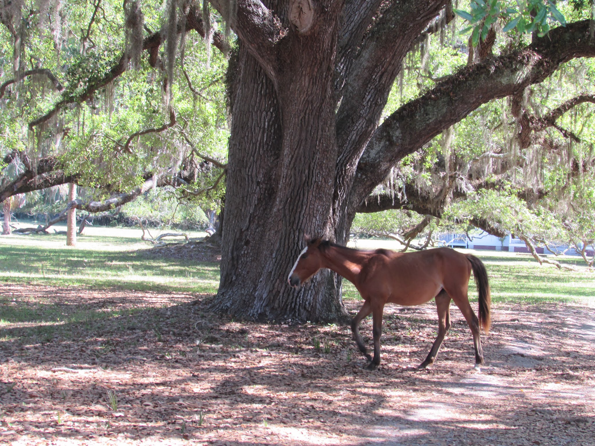
As we wandered along the designated paths on the southern part of the island, it was fun to see many animals, including a raccoon, salamanders, armadillos, a few glimpses of deer, and, of course, the wild horses, that freely wander the island. Birdwatching, too, was fun. The mixture of ecosystems means that there is a wide variety. Eating lunch beneath the twisted limbs of the live oaks, we watched in astonishment northern parulas feeding their young. Breezes bring salt air that stunts the growth of the trees, creating a complex puzzle of twisted branches as they seek more sun. The trees create shade and relief from the punishing sun and heat. Although their breeding area covers Pennsylvania, I have never seen a northern parula in the state. With a diet consisting of insects, they are particularly fond of Spanish moss during the breeding season, which is plentiful on the Island.

Northern Parula chick waiting to be fed

Despite an abundance do wildlife, most of the signage on the island points the visitor’s attention to the legacy of the Carnegie family. In some ways this is a clever dodge, to divert people from concentrating on the years of slavery, plantations, and the treatment of those who were not powerful. However, a small sign at the dock, often missed because it is not in the direct line of sight when one leaves the ferry, explains to the visitor that human occupation of the island has occurred for several centuries, and this place was once called Tacatacuru. But the sparse amount of information about the Timucuan people reveals had little is known or understood about the culture and the lives of the people. Europeans began to arrive in the area during the sixteenth century, and most of our knowledge about the Timucuans, their language and culture is filtered through those European eyes. The large Spanish Mission of San Pedro de Mocama, which introduced Roman Catholicism to the local population, was part of the imperial contest for land, wealth, and influence in North America. Its exact location remains undiscovered, but its existence dominated political relationships and was a symbol of ownership in Spain’s struggles with the French and British colonial interests. 

While this nod to indigenous history raises interesting points, it is the histories of the nineteenth and twentieth centuries that demands most of the park’s attention. The backdrop of slavery and the American Civil War plays a part in the island’s history, especially since Robert E. Lee’s father was interred on the island for a time. But it is the post-war industrialization of the country, and the rise of rich industrialists that figure prominently. Thomas M. Carnegie, brother of famed philanthropist Andrew, began building a 59-room mansion called Dungeness in 1884. Its dock is the one used by the National Park Service to ferry passengers from St. Marys each day. Thomas died just two years later in Pittsburgh, never seeing his vacation home completed. His wife Lucy, along with nine children, would finish the project as well as several others on the island. In the years that follow, she oversaw the construction of other estates for her children, including Greyfield, Stafford Plantation, and Plum Orchard. The story of the Carnegie family is fascinating and reaches into the core of many American towns with the libraries built by Andrew Carnegie’s fortune. It made his name familiar, and his legacy remains relevant as the architecturally appealing libraries demand protection and restoration more than a century later.  

Dungeness today
After Lucy’s death in 1916, Dungeness largely remain unoccupied. Her daughter Nancy’s wedding was held there in 1929 as the last major event in the mansion’s history. It was destroyed by fire in 1959. While the ruins are off limits to the visitor, it is fun to peer inside and have a look at faded glory. As I circumnavigated the nineteenth century mansion, a monument to industrialization and grad wealth, it struck me we rarely think about our homes in the future, after we are gone. In all probability my home will exist after I am gone, but what is its fate? Who will live there? How will it come to an end? I watched the wild horses graze in the front lawn by a fountain that has not worked in an exceptionally long time as I thought about it. I imagine they are saying to themselves, “yet another human taking photos of ruins that we see every day.”  I know they do not, but why do we feel compelled to photograph, consider, and ponder the ruins of such a mansion? One cannot help but think about Citizen Kane, surrounded by all his physical treasures in his old age, many of which will end up in the incinerator.

Wild horses roam the grand front yard of Dungeness

The now abandoned settlement of High Point, an abandoned black community on the north end of the island, is likewise compelling. Founded in the late nineteenth century, the community consisted of former enslaved people and their descendants. The focal point of the site, which is under the auspices of the National Park Service, is the First African Baptist Church built from salvage lumber in 1937. Located fifteen miles north of the ferry dock, the community is difficult to access, especially so for day trippers to the island.

One of the estates where blacks on Cumberland Island would have worked as servants and caretakers was Plum Orchard, the home of George Lauder Carnegie. He was the son of Thomas and nephew of Andrew Carnegie. George married Margaret Copley Thaw, who was widowed in the early 1920s. Margaret left Cumberland Island, traveled, and spent time in New York City after George’s death. Two years after her husband’s death she married the Count de PĂ©rigny and became a Countess; however, the following year she was sued by Madeline Modica for alienation of affections. Her husband, a car salesman, had developed a friendship with Margaret. But the New York newspapers were skeptical that she would have had a romantic relationship with Emmanuel Victor Modica describing him as “dark, has large eyes and is of slender build,” presumably suggesting that an affair with the countess would be shocking. In the race conscious 1920s, recent Italian immigrants were not considered acceptable marriage or companion materials for society women. Shortly after the scandal, Margaret and her new husband left the United States and settled on his farm in colonial Kenya where she died in 1942.

Wilson's Plover

Royal Tern

Northern Parula

A brown-headed Cowbird catching a ride on a wild horse


Tuesday, June 26, 2018

C&O Canal Towpath: Spring (84 – 91)


Mile Marker 84
Early spring found me beginning at mile marker 84, just downstream from Dam Number 4. It had been a particularly tiring week and the current of the Potomac, so short a distance from the dam, was very swift making a languid pace seem almost lazy. The first signs of spring were beginning to appear: bluets and dandelions had begun to poke through in grassy areas. I watched an interesting insect, with a body of brick red, matching my speed a few feet in ahead. There is an instinct among humans to view most insects as nuisances or threats. I watched for a few brief seconds before it veered away from the path. Although yet another sign of spring, since the lives of most insects are measured in days, I realize that it would not live to see the autumn. It is an odd perspective to consider; human lives, for millennia, have been calculated on the cycle of seasons. It is difficult to imagine a creature whose existence will not allow for the comparison of one season to the next.


Dam Number 4 (84.6)
Dam Number 4
Constructed in 1836, the masonry Dam Number 4 spans the Potomac creating a large pool of water upstream known as Big Slackwater, which is popular for fishing and boating. On the West Virginia side of the dam is a power plant built in the early twentieth century. The water rushing over the dam, creates the downstream inundation, and a tremendous roar making the dam heard before seen. I stood and pondered a child’s blue ball, caught in the torrent of water rushing over the dam, bobbing up and down. There seemed to be no hope of escape for it. How long would it take for its release?

A small parking lot is located at the dam, and the road that leads to it, appropriately named Dam Road Number 4, runs parallel to the canal and towpath for about a mile and a half. Small houses and trailers dot the road, and people are busy with their Saturday chores. Across the river, magnificent sheer cliffs line the West Virginia side.

At Weir Inlet, the canal disappears for 3.1 miles. Thus, the creation of the Slackwater, which is so calm that it allowed boats to navigate the river. The towpath continued so that mules continued the journey. But it was a difficult journey because of the high cliffs that lined both sides of the river. It is here that four teenagers join the trail about a hundred yards in front of me, from a boat ramp parking lot, walking a small chihuahua. The lone boy in the group, estimated to be about 12 or 13, was throwing rocks trying to land them into the narrow Guard Lock 4, as boys that age are wont to do.

As I approached mile marker 86, my days of restaurant work came back to me. The number 86, often used as a verb, is shorthand for something that was no longer available on the menu. Early in my foodservice career, I asked about the origins of the term, to which the replies were nothing more than blank stares, an indication of my lack of expertise and knowledge, before returning to the mad scramble of behind the scenes kitchen work in a busy restaurant. One popular theory is that the term might have originated from Chumley’s, a speakeasy in New York City, where bartenders were told to 86 the customers before a raid, meaning to have them exit the establishment at 86 Bedford Street to elude the police.

Just before arriving at the mile marker, I noticed a large piece of Styrofoam laying a few feet from the shoreline. More than likely it had washed up during the past couple of weeks of heavy rains and melting snow. I resolved, as my effort at being a good citizen and steward, to retrieve it on the return trip and dispose it properly. Measuring about four inches by four inches square, and about eighteen inches long, it was obviously not heavy but a little awkward. I felt a bit strange lugging this large piece of Styrofoam back the three-quarters of a mile to the Slackwater Boat Ramp, where restrooms, and presumably trash receptacles, were located.
Juvenile bald eagle

A juvenile eagle skimmed the river nearby. I place the piece of Styrofoam at my feet and fumbled for my camera. What would have been a great photograph, became a mediocre one of the young eagle sitting in a tree on the opposite shoreline. I picked up my piece of refuse and continued, noticing a few paces away the jetsam that had gathered near Weir Inlet: a red soccer ball, another piece of Styrofoam, two plastic water bottles, a yellow plastic canister of motor oil, and a dead catfish. I was not going to wade into the water to retrieve more material but intended that my act was a small token gesture. To my surprise the few people I did pass mentioned nary a word about my strange object. In fact, most did not even speak. Perhaps because I was seen as a strange man carrying something odd.

There were no trash cans at the boat ramp, nor would there be the parking lot at Dam Number 4. On the outward trip, a kingfisher flew overhead; I recognized it more because of sound rather than sight. Carrying my piece of Styrofoam, I again heard the distinctive cry of a kingfisher and caught a glimpse, through the trees, of a slate-blue bird flying along the canal. With some difficulty, I placed the Styrofoam under my left arm, and carried my camera in my right hand, chasing an elusive kingfisher. I watched the flight of the bird and projected a landing perch. Just as I did, I heard the rattled call and saw a bird closer than I expected. What I had assumed was one bird, but was actually at least two, leapfrogging each other along the course of the canal. Again, I sat my refuse in the middle of the path, along with my backpack, to signal my return, to set off for what turned out to be more mediocre photographs.

Returning to my car, finding no trashcans or recycling bins, I placed the piece of Styrofoam I carried for about 1.7 miles in the back of my car for the 45-mile journey back home. There was a subtle piscatory smell emanated from the back of my car as I drove home, where I would deposit the refuge in my recycling cart for a Tuesday morning pickup. For some reason, the sanitation truck did not come on its appointed day; arriving home from work Tuesday evening I noticed the recycling bin with the bulky Styrofoam still preventing the lid from closing completely. “No good deed…,” I thought. Good news, however, recycling was collected the following day.


Virginia Bluebells
In the intervening two weeks since I was last on the trail, many things have changed. After many false starts, spring appears to have finally sprung; trees are budding, there are several boaters and fishers on Slackwater, and it has become imperative to dodge cyclists on the trail. At home, we have adopted three kittens. As I walk I have daydream about Pip’s crystal blue eyes and her tiny brown paws that resemble miniature versions of bear paws. I see Lucie and Coco’s doleful faces looking at me with trepidation and trust.

Shooting Stars
For about a mile and a half, the towpath is a concrete bridge that skirts the shoreline of the Maryland side of the Potomac. My attention is drawn to the newly emerging wildflowers, rather than the birds today. I scan the rugged cliffs and hillsides along the Slackwater; it is nice and rather warm. An informational sign points out that the proximity of the cliffs and the river creates a unique space for wildflowers to prosper. After reading the sign, I looked around to notice that there were plenty of dandelions and violets, but nothing that I would consider particularly rare. Yet, within a quarter of a mile I began to observe several Virginia bluebells. I stopped to watch a bumblebee make its round of newly blooming shooting stars, a white flower with yellow core. When I was a kid, the bumblebee was an object of fear, more menacing than a honeybee. But today, understanding more about the pollination function of bees and the increasing environmental pressures on bees, I find the bumblebee fascinating.

The trail between mile markers 87 and 88
Several people were out, walking and cycling. The concrete bridges are a little intimidating with cyclists because many treat the trail as a racecourse. A couple on foot, approximately my age, become quiet as we approach one another. My suspicion that their discussion is sensitive is confirmed after I pass the two I heard the woman say, “That’s not the kind of stories you tell around young kids…”


McMahon’s Mill (88.1)
McMahon's Mill 
Just upstream from the McMahon’s Mill, three young men, in their early twenties, with a girlfriend along, were using a tree at a fifteen-degree angle to swing out over the river and jump in. Someone had nailed planks to the tree so that it could be easily climbed. The three, two wearing swim trunks while the other was simply donning his Hanes boxer-briefs, were drinking Rolling Rock and taunting each other. Two cyclists had stopped to watch, and despite the attempts to engage with questions like, “Is it cold?” they were largely ignored. Instead, as I passed, the young men were conversing about techniques and methods. One had decided to climb higher so that he could jump directly from a tree branch in to the Potomac. He dropped his half drank beer to his friend, extolling him not to waste it. His friend advised, “Hold your hands out, after you jump,” presumably preventing him from hitting the bottom too hard. Seconds before he released, his friend retorted, “I know how to f***ing jump.” On my return trip, not too far from the tree where the young men were jumping, four young women, in swimsuits, were sitting on the edge of a concrete embankment, sunbathing, chatting, and simultaneously absorbed with their phones. I caught up with the three young men later, having a good time, perhaps aided by the Rolling Rock, engaged in lively banter. The young woman with them tried desperately, but unsuccessfully, to secure the attention of her boyfriend as they neared the parking lot. 

The following week, in late April, I returned to find that the rains of the previous few days, along with snow flurries, has resulted in a flooded towpath. A layer of mud covered much of the path, some of the path and concrete had been washed away, trunks and large branches had been washed ashore. I abandoned my walk after about half a mile when I discovered that water still covered a substantial portion of the trail. Instead, I opted for a walk on the surrounding backroads near McMahon’s Mill (see below).

Locks 41 and 42 (89.9)
Remnants of Lock 41
Because of travel and weather, it was mid-June before I returned to McMahon’s Mill. Despite it being several weeks later, the trail had not improved much. It was a rainy spring; the path was muddy, and water had recently covered the path. Yet, it was a little more passable that it was several weeks before. Nevertheless, a light rain, combined with the mud made footing walking difficult, slippery and slow. I calculated that if I could make it to Locks 41 and 42, where the canal resumes shortly before mile maker 89, then the path would be better. My calculation was correct; however, what I did not account for was the amount of water that laid stagnant in the canal. In some places, it reminded me of the swamps of Georgia and Northern Florida.

Downed tree (June 2018)
Shortly after gaining the high ground alongside the two locks that I found that a gate was across the path with a sign indicating the path was closed because of dangerous conditions. There was no such sign preventing people going upstream from McMahon’s Mill. I decided to press on, because at that point I was not in the restricted zone. Soon I met a group of Boy Scouts cycling the opposite way. I wondered how they would fare through the mud. No doubt, at least some of them wondered how I would fare through the swamp.  Soon, despite having some repellent on, mosquitoes were not dissuaded. As I walked through swarms of the pests, I could feel tiny collisions on my bare arms and legs. The further I walked, the more mosquitoes I found lighting on me. I saw a male Baltimore Orioles on a branch just a few feet in front of me. I slowed down to take my camera out, and instantly two mosquitoes were on my hand. To stand and gaze at anything was to be a stationary target for hordes of mosquitoes. The best thing to do was to keep moving, at a good pace, to avoid as many mosquitoes as possible. Nevertheless, an observer might have thought I was a crazy man, flailing his arms around as I moved quickly through the two miles past Locks 41 and 42. When I reached the Opequon Junction Campsite I turned around and repeated the gauntlet in the opposite direction. I had visions of having dinner that night with friends, constantly scratching a mass of mosquito bites on my arms and neck. I was about twenty-four hours too early in my calculation, the itching started the next afternoon
.

Again, the path downstream of Lock 42 was muddy, but with significantly fewer mosquitoes. I decided that perhaps for the summer season I should concentrate on a different part of the trail. I would return to the 90s when autumn arrived, and insects were less of a nuisance.


Accessing the Trail


Log cabin on Dam Number 4 Road
Dam Number 4 Road has many springhouses and rock fences along the way. In Downsville, there is a general store and old school. (road becomes Downsville Pike MD632)

Avis Mill Road, which confusingly leads to McMahon Mill, parallels the Downey Branch Creek from Dellinger Road to the river. Several bluebirds and swallows flitted around open fields of Dellinger Road

Walking along Dellinger Road, I contemplated that I could be a person of concern for many as I wandered these roads. I anticipate questions, such as “What are you doing here?” But no questions ever come. For the most part, people drive by, give me plenty of room to walk on the road, and a polite wave. I assiduously wave back, calculating that it would ease the minds of those driving by. One of my colleagues had just returned from Scotland and we had a brief conversation about the “right to roam,” a concept whereby people are legally able to trek and hike on public or private lands for exercise and leisure. This is an anathema to most Americans; the number of “no trespassing” signs posted around the path, as well as across the United States, is a sign of the emphasis on the place on property and, ostensibly, privacy. As a curious walker, I like the idea of a right to roam; however, while in Scotland it is difficult to acclimatize myself to the idea. I walk across fields wondering if someone will show up to ask me to leave, or worse call the police. 
Rock Fence on Dam Number 4 Road


Tuesday, June 19, 2018

Walking the Royal Canal (Part 2)


On an overcast day, a little over a week later, I returned to Mullingar to explore more of the canal. My ambitions were high that afternoon: to walk from the center of town to a small pub, Mary Lynch’s, approximately seven-and-a-half miles toward the east. The weather was cooler, a pleasant 63°F, and the only demands on my time was the bus schedule to allow me to return to Mullingar at a reasonable time.
The previous week I had walked to where the N52 crossed over the canal and path, approximately a mile-and-a-half out of Mullingar. Thus, tried to move swiftly through the area, and it seemed to take forever to get back to N52. On my previous walk I had been concentrating on birds. This walk I became fascinated with the windflowers and the bees that roamed from flower to flower.

Quickly, it felt as if I were walking in remote areas. Probably because it was a Tuesday afternoon, I saw very few people on the trail. There were several overgrown paths leading from the trail, most were overgrown and appeared not to have been used in quite a while. In Scotland, the right to roam makes it less daunting to explore the odd and intriguing path. The idea is that as long as you are recreating, committing no harm, you can walk virtually anywhere in the wilderness. But this does not apply to Ireland. There are far fewer no trespassing signs, or signs warning to beware of dogs, then in the United States; however, there are some. I overcame my trepidation and took a side path, which was not particularly well marked, up a hill. What did I find at the top of the hill? Nothing more than a field, or perhaps it was a pasture. My curiosity was in unrewarded. Of course, how would it have been rewarded unless I had taken a look?
Marlinstown Bridge
Earlier in the day, at a convenience store in Mullingar I bought a ham sandwich and a bottle of water. The elderly gentleman who sold me the sandwich, said it was a nice day. I retorted it was an excellent day for a walk. A big grin came across his face as he said, “Enjoy the walk, and God bless.” I stopped for my lunch at Marlinstown Bridge, a one-lane bridge in a remote area. Yet, a service truck crossed the bridge and a man and his dog walked by. I wandered to the other side of the bridge and found a trailhead to a wilderness path along the high bank of the canal. A few bug mansions and bee hotels had been built to help promote local biodiversity.

The path opened into a wide valley, where it ran alongside several pastures and farms. I was thinking that I had not seen many aquatic birds along the canal, other than a pair of swans on the west side of Mullingar the week before. Then, within seconds, I spied a grey heron, who did not allow me to get to close to photograph before flying off. Many of the nature signs along the canal touted the multicolored kingfisher as being native, but elusive, to the area. Although I kept looking I was disappointed by not seeing the European cousin to one of my favorite birds. In fact, the crane would be the only aquatic bird I saw during all my walk on the canal.
The N4 highway approached closely, and ran parallel to the path in this area, and it was hard not to be distracted by the noise. I saw another stone marker, which was impossible to read. I noted, however, that today in Ireland every half kilometer is denoted along roads N4 and the stone markers would probably outlast the metal signs that currently gave motorists their whereabouts.
The Downs Bridge
As I approached the Downs Bridge, the path served as a paved one-lane road used by a few houses. At one point, a bush hog mowing the grass along the edge of the road patiently waited for me to pass. I was glad he did. After I passed I heard the mower hit some glass bottles and aluminum cans, the shrapnel would have hurt I am sure. A little bit further, several trucks were repaving the asphalt on the Downs Bridge. An older worker sitting on the back of a truck greeted me. I asked him to confirm that I was the Downs Bridge, which he did. He inquired as to if I were having a good walk but the look on his supervisor's face suggested that we should keep the conversation short.

Here and there houses told stories about their occupants and the land. A white house with yellow trim caught my eye and sparked my imagination. The house had several additions and four rather large pine trees, which looked out of place in the Irish countryside, which were planted a generation ago. The back of the house, typically known as the garden, was full of flower pot and plants. An old sliding board, with faded red paint, was being consumed by grass that had not been mowed in a quite a while, indicating that the children no longer lived there. But a newer, small green table with two chairs overlooked the canal. I imagined an elderly couple taking their afternoon tea or evening drinks while watching wildlife or the cyclists pass.
A hand-cranked drawbridge
Shortly before automobile access to the path ended, I passed a bridge that had an intact hand crank drawbridge that would allow cars to traverse the bridge when down, its current state, and boats to pass when raised. I was mesmerized by this old structure and was thinking about how to describe it. I took several photographs, from different angles, to demonstrate how it worked. In my head, I was imagining a conversation with my dad, trying to explain the design to him, who would have been deeply interested.

Between the Downs and McNeads Bridges, the canal sat high above the valley floor. Several culverts allowed small rivers and streams to pass beneath. Since this section of the canal was completed by 1817, I pondered the work and planning that went into its creation. I am unclear about the conditions under which the canal was built and who did the labor. But It was a reminder that early nineteenth-century canals were a marvel of engineering. I walked between the Royal Canal's successors: to my right was the railroad tracks, which later in the nineteenth century would make the canal obsolete; to my left, the N4 highway that took the modern traveler, whether my bus or car, to destinations throughout the island.
Toward the end of my journey, I realized how glad I was that it was not sunny. Although it was not optimal for beautiful picturesque photographs, it made walking much easier. I was not prone to being too hot or having an Irish sunburn. Besides, the cloud cover did make it easier to photograph some of the wild flowers without shadows. It also made it easier to continue the journey. I arrived at Mary Lynch's pub a full hour and a half before the next bus was scheduled to arrive. I had walked a little over seven miles at that point but did not think that ninety minutes in the pub was a good idea.

A pied wagtail at Lock 25
After a few minutes, I started to slowly walk to the next bridge, another two kilometers further. After a few minutes I resumed my natural pace but was beginning to feel the toll on my feet. When I reached Lock 25 (Loc 25), I decided that it was enough of a walk. My day would end with a total of 9.8 miles.

Mary Lynch's Pub
I returned to the Mary Lynch Pub with about an hour before the bus was set to arrive. I few people were around the bar, and I ordered a celebratory Guinness to pass the time. The bartender, who said she saw me walking earlier, asked me how I enjoyed my walk. I replied that it was a nice day for walking. She gave me a detailed summary and update of the weather, noting that previous week had been too hot for many people. The pub had had several walkers and cyclists who could not cope with the extreme (for Ireland) temperatures.

Mary Lynch's Pub
The bartender told of a woman who, while cycling with her husband the previous weekend, got cramps and light-headed. Her husband gave her a "fiver" and rode his bike home to retrieve the car. An hour and a quarter later he came back. One of the women at the bar comment, "An hour? She needed more than a fiver." The bartender went on to tell me that, "High pressure will be building tomorrow night and will be turi-bill winds. It will blow itself out by Turs-day morning. Sunny weather then, but cooler." Her forecast was pretty much right.

She took care of other guests and nursed my beer. I went out to catch the route 115 bus at 17:52, five minutes early. Even though I knew the stop was near the end if the route and it highly unlikely to be on time. After walking nearly ten miles, I neither wanted to miss an on-time bus nor consider a 7-mile walk back to Mullingar. I have been riding buses in Ireland for over 15 years and feel confident about understanding the nuisances of doing so. But I have to admit, with my feet aching, watching cars zooming by coming home from work, when the bus was twenty minutes late I began to have some doubts and trepidation. But when the bus rounded a bend in the road, thirty-three minutes after its scheduled arrival time I was happy to pay my €4.30 to return to Mullingar.

Saturday, August 30, 2014

August Explorations

Spence and I had a good week exploring some classic Americana sites. We had lunch at Eddie’s Diner, Wilkes Barre, Pennsylvania, that looks like a classic diner that has been remodeled, updated and has had substantial additions. In the original section, there are three booths to the right and a cashier stand with two additional booths to the left. There are 18 affixed stools along the straight counter, with a banner behind the counter noting the 25th anniversary of the diner (in 2012). The primary color scheme of the diner is a dark pink set against the stainless steel fixtures. Eddie’s Diner offered Spencer is first opportunity to try Birch Beer, which I think her enjoyed. The diner was busy and the servers knew many of the patrons by name.
The following day we made our way to Crystal Grottoes Caverns just outside Boonsboro, Maryland. The cave was discovered on 18 September 1920 when workers, excavating limestone to build Route 34, broke through and felt cool air emerging from the ground. After exploring the caverns, excavations were halted with the provision that the cave would be open to the public. The cave’s first day of business was 2 April 1922 when tourists were charged 7 cents to enter. Because no humans entered the cave until the twentieth century, many of the formations are pristine. This small roadside attraction, the only caves open to the general public in Maryland, is both fun and educational.
Just a few miles away stands the first completed memorial dedicated to George Washington on South Mountain.  Washington Monument State Park, located in Middletown, Maryland, was built by the citizens of Boonsboro on 4 July 1827. The more famous monument, the marble obelisk in Washington DC, was built between 1848 and 1884. Standing fifteen feet high at the end of the day, the Maryland monument was completed in September of that year can stood thirty feet. It has fallen into disrepair from time to time and was most recently rebuilt by the Civilian Conservation Corp in 1936.
A fellow visitor at the
Washington Monument
Holsum Bread Advertisement at Keystone Stores
The monument, which you can climb to the top of, offers a beautiful view of the valley below. Unfortunately, on the day we visited, the mountain was shrouded in clouds and fog. Every so often, the clouds would momentarily part to offer a tantalizing view of the valley below.
Our week ended with an exploration of the small borough of Pine Grove Pennsylvania. Among the interesting sites in the town was the Pine Grove Theatre, opened in 1910 and the Keystone Stores, an old grocery store that still has many of the old advertisements in its windows.