 In New York, sometimes it seems
that real gems are obscured by the obvious. Earlier this month, I was interested
by all the people milling around the 9/11
Memorial Site. The recently opened site intends to honor the victims of that
terrible September morning in 2001, complete with an office tower and a
shopping mall. Virtually every tourist was taking the same photograph, over and
over again, from the same perspective, of the newly completed Freedom Tower. I did
not see anyone who noticed the architectural gem at 90 West Street, which was damaged
during the 9/11 attack as well. The building opened in 1907 and was designed by
architect Cass Gilbert. The primary tenant was the Delaware, Lackawanna and
Western Railroad and it also housed Garret’s Restaurant, billed as the highest
restaurant in the world at the time. Its
magnificence is obscured by other tall buildings and the distraction of other
sites in lower Manhattan.
In New York, sometimes it seems
that real gems are obscured by the obvious. Earlier this month, I was interested
by all the people milling around the 9/11
Memorial Site. The recently opened site intends to honor the victims of that
terrible September morning in 2001, complete with an office tower and a
shopping mall. Virtually every tourist was taking the same photograph, over and
over again, from the same perspective, of the newly completed Freedom Tower. I did
not see anyone who noticed the architectural gem at 90 West Street, which was damaged
during the 9/11 attack as well. The building opened in 1907 and was designed by
architect Cass Gilbert. The primary tenant was the Delaware, Lackawanna and
Western Railroad and it also housed Garret’s Restaurant, billed as the highest
restaurant in the world at the time. Its
magnificence is obscured by other tall buildings and the distraction of other
sites in lower Manhattan.Thursday, June 26, 2014
Hidden New York
In New York, sometimes it seems
that real gems are obscured by the obvious. Earlier this month, I was interested
by all the people milling around the 9/11
Memorial Site. The recently opened site intends to honor the victims of that
terrible September morning in 2001, complete with an office tower and a
shopping mall. Virtually every tourist was taking the same photograph, over and
over again, from the same perspective, of the newly completed Freedom Tower. I did
not see anyone who noticed the architectural gem at 90 West Street, which was damaged
during the 9/11 attack as well. The building opened in 1907 and was designed by
architect Cass Gilbert. The primary tenant was the Delaware, Lackawanna and
Western Railroad and it also housed Garret’s Restaurant, billed as the highest
restaurant in the world at the time. Its
magnificence is obscured by other tall buildings and the distraction of other
sites in lower Manhattan.Tuesday, June 10, 2014
Thinking about Holmes and Experiences
As this year’s sojourn to Europe
comes to an end, I refer back to my old literary friend Sherlock Holmes. In The Adventure of the Red Circle, Holmes
reminds his friend that, “Education never ends, Watson.” With
that I am reminded that in each new travel experience we are exposed to new
things and increase our knowledge and understanding of the world. Perhaps this is why I (and many others) enjoy travel so much,
because it is a high dosage of education. Why else navigate alternative
transportation options to spend less than twenty-four hours in Malmö? Because it is an opportunity to see something
new, to experience other things, to learn something.
At the airport in Copenhagen,
there is a commemorative display to Danish writer, and national hero, Hans
Christian Andersen. The display notes that Anderson made more than thirty trips
outside Denmark in his life. This
had a profound effect on Andersen and he wrote that travel enriched him and
made him happy. In The Fairy Tale of My Life (1855), he concluded, “To travel is to
live.”
These nineteenth century
literary references tells us of the importance of discovery, experience and
knowledge. While phenomena
of travel and discovery has substantially changed from the nineteenth century, the
basic human need to learn and explore has not. Yet, we would do well to remember that the act of travelling does
not require us to go far. It is a state of mind. Any journey, even as short as
fifteen minutes, can be a travel experience. It depends on the sojourner’s
attitude: Are we willing to see something new? Willing to explore? To learn
something?
It is also worth noting that
Doyle has Holmes quote Shakespeare near the end of the Red Circle: “Journeys end in lovers meeting.”
Monday, June 9, 2014
Endangered Species 2014
Following a post
from last year about the declining number of telephone booths and postal boxes,
particularly in the United Kingdom, I found some more examples. This time the condition
of each seems more aesthetic than functional. In both Stockholm and Malmö I
came across these Rikstelefon booths (neither actually had telephones in them).
The booths were located in the old town sections of each of the respective
cities.
 |
| Stockholm |
 |
| Malmo |
 |
| Moate |
Additionally, in Moate, Ireland,
I found this Victorian era mail slot that was no longer in use. My journeys
also took me to the Postal Museum in Stockholm, where I observed several
interesting specimens of postal history. In one room a quote about stamp
collecting from Charles J. Phillips was painted on the wall: “The King of
Hobbies and the Hobby of Kings” (1936). Given the decline in mailed letters and
letter writing, and the use of personalized stamps, it seems doubtful whether
philatelic pursuits would be popular in the future.
Sunday, June 8, 2014
Copenhagen Central Train Station
A train station is an
interesting crossroad of people on the move, especially in Europe. Travelers
and commuters converge at stations. All types of people walk through, from the
young girl in her early teens in full makeup, carrying a soccer ball and cleats,
to the elderly man who meanders from shop to shop, occasionally checking the
departure board, in no particular hurry. Watching people in a train station is
always fun and interesting and there is no telling who and what you are likely
to see.
 When it is close and my hotel
has an overpriced breakfast, I sometimes duck into a train station to have a coffee
and croissant for breakfast. This was the case on a recent Saturday morning in
Copenhagen. Sitting in a coffee shop at a window seat, I watched travelers meet,
search, shop and hurry off to catch trains to their destinations. As my previous
posts have indicated, I like train stations: It is a place of waiting, and
a place of rendezvous.
When it is close and my hotel
has an overpriced breakfast, I sometimes duck into a train station to have a coffee
and croissant for breakfast. This was the case on a recent Saturday morning in
Copenhagen. Sitting in a coffee shop at a window seat, I watched travelers meet,
search, shop and hurry off to catch trains to their destinations. As my previous
posts have indicated, I like train stations: It is a place of waiting, and
a place of rendezvous.
Train stations contain symbols
of, and information about, the city and culture they inhabit. Copenhagen
Central Station is one of the busiest I have experienced. I have heard more than one person say that
there is always a line for tickets. Yet, most people are helpful and patient. Even
though the majority of passengers are people, it is also a place for dogs. Sometimes
the canine passengers seem more excited about their travels than their human
companions.

Opened in 1911, the main
Copenhagen station is composed of brick, steel painted brown and a brownish red
tile for flooring. The ceiling has slats that appear to be made of wood. It
gives the station a surprisingly dark effect.
An interesting note: A smoking
ban on the platforms will not come into effect until 1 July 2014 (it is
surprising how many people were smoking).
Saturday, June 7, 2014
Remember the Camps in Denmark
 In looking over my posts for
this year’s trip to Europe, I noticed that I have not mentioned the Holocaust in
any great detail. My only entry on the subject this year will be the
nondescript plaque in the churchyard of Helligaandskirken (The Church of the
Holy Ghost) in Copenhagen. There is no other explanation, except: “Tomb of the
Unknown Concentration Camp Prisoner” in four languages. It is an interesting
contrast to the Tombs of Unknown Soldiers in many countries.
In looking over my posts for
this year’s trip to Europe, I noticed that I have not mentioned the Holocaust in
any great detail. My only entry on the subject this year will be the
nondescript plaque in the churchyard of Helligaandskirken (The Church of the
Holy Ghost) in Copenhagen. There is no other explanation, except: “Tomb of the
Unknown Concentration Camp Prisoner” in four languages. It is an interesting
contrast to the Tombs of Unknown Soldiers in many countries. Friday, June 6, 2014
Riding Bus 20
The bus that runs between Dublin
and Galway for Bus Eireann is designated Route 20. There is an express bus
(X20), which only stops in a few major destinations; however, the regular
service winds through many small towns and back roads. These buses are well
used, but not overly crowded. A few years ago, as I was riding Bus 20, I began
writing down notes on each town, what was there, facilities, hotels, and pubs
to help me select a town to spend a few days exploring and relaxing. It has
become a way to gauge the economic health of the midsection of Ireland. From
one year to the next, I can note the prominence of restaurants, cafes and pubs.
This year my ride from Dublin to
Athlone was on a bus that was about half full, on a Friday during the mid-to-late
morning. We left Busáras (the main station) at 10:30 and made our way along the
docks before turning into the tunnel heading to the airport. As we approached
the terminal, there was a good sized protest march by Aer Lingus cabin crews,
supported by the pilots. The cabin crew were striking for better working conditions
and formed a long line marching to the airport. The strike disrupted many
flights that day.
As we departed Busáras there
were two elderly men sitting at the back of the bus having a lively conversation.
As the bus got underway in earnest, the conversation was muffled by the sound
of the highway. I could hear the men talking, but I had no idea what was being
said. But in their Irish accents it was as if the two mean, with worn faces had
stepped off a movie screen.
After a few stops at
intersections and a school, the bus came into Enfield. The town has many
well-kept houses with nice gardens. The bus stop is at the Street Side Café, a
seemingly inviting place to enjoy a sandwich and a tea after a bus ride. The
town also has a canal or river with a walking path that runs on the western
edge of town, as well as a train station.
Kilbeggan has a whisky
distillery on the edge of town that is a tempting tourist destination. As we
pulled into town, the bus sounds die down enough so that I can once again
understand the conversation between the two men at the back of the bus:
“How old is she now?”
[I could not understand the
answer]
“I don’t believe it… (long
pause) …she’s a pretty girl.”
The bus made its way through
Moate, an old market town, and then onto Athlone. As we pulled into the bus station,
the conversation once again was audible. One of the men was lamenting the
changes in the world: “It’s a different way of life…they don’t take the time to
talk.”
Thursday, June 5, 2014
Moate Hill Road
I was examining my map, looking
for interesting walks in and around Moate. I noticed Moate Hill Road, which was
not immediately on my list, but it did go south and all of my previous walks
had been on the north side of the city. Upon studying the map further, I had
difficulty determining where the road actually was. According to my map, the
road started directly across from my hotel (Grand Hotel, Moate); however, at
first glance, I did not see it. This, in fact, sparked my interest and it
turned out to be one of my favorite walks of the trip. The road was, indeed,
right in front of the hotel, situated between two buildings. To an American set
of eyes it looked to be a private drive. As I traced the route, I thought it
was also interesting that the road crossed the M6, the major highway between
Dublin and Galway.
 |
| The beginning of Moate Hill Road |
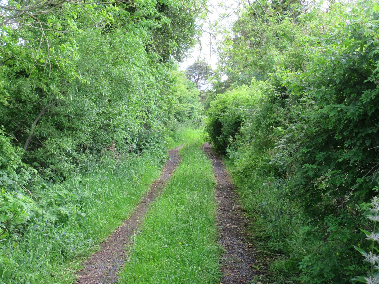
Moate Hill Road starts between
two buildings in the center of Moate, Walshs clothing store and a currently disused
building that was being worked on during my exploration. Within a few hundred
feet, the city center traffic was left far behind and the Irish countryside was
at hand. On the road, there are a few scattered houses and only one business
(other than farms): Riverpark Kennels & Cattery. Walking through the
countryside and beautiful trees there was a sense of solitude. My only company
was a curious white horse and a few cows. Of course, there were plenty of birds
as well.

The road gently winds and begins
to become a bit less travelled as you move away from Moate. Eventually, it briefly
turns to gravel. As I approached the M6, however, it was a little intimidating
because Moate Hill Road turned from a gravel road to a wide, paved road with a
stripe down the middle in a matter of a few feet. I assumed that this meant
that there would be a lot more traffic. Yet, after the road crosses the M6 it
narrows again. It is almost as if the bridge across the road were completed so
that if Moate Hill ever needed to be widened, it would not affect M6. The
chances of this happening in the foreseeable future seems remote.
 |
| The final portion of the road |
About 700 feet after crossing
the highway the road, once again, has grass growing down the middle. There is a
single occupied house on the south side of the M6. Then, slowly, the road
narrows, becomes overgrown with grass, and the pavement turns to mud. A few
yards later, the road ends at a derelict farm. The farm buildings look as if
they have not been used in a couple of decades and the house, without doors,
has been partially overtaken by trees and bushes.
 |
| The derelict farmhouse |
I liked the walk so much that in
the afternoon I repeated it. The total length of the road is 1.1 miles. I
remained respectful of the derelict property, but there was a temptation to
explore the farmhouse. I am still unclear as to where the hill, in Moate Hill
Road, is/was. During both walks, I only encountered one automobile, driven by
an elderly man. On my afternoon walk, I met a father and two young daughters
(aged 6 and 8?) riding their bikes over the M6. Both little girls were
struggling to get their small bikes to the top of the bridge. The walk was one
of the great experiences exploring on a whim, not always rewarded but something
to experience.
 |
| On the return trip, entering Moate |
Wednesday, June 4, 2014
Coosan Point / Lough Ree Park
 |
| Coosan Point Road, with the church in the distance |
After seeing a sign for Coosan
Church, I altered my plan and decided to take a chance to see if it was an
older church (perhaps from the 18th or 19th century). This meant that I was
abandoning my intended plan to walk along the Shannon River in West Coosan.
Nevertheless, the path to the church was on Coosan Point Road, and armed with
an iPhone, I decided to follow that road to the end. Very soon after turning
onto the road the church came into view – it was not 19th century. In fact, the
sign out front read: “Our Lady, Queen of Peace, Coosan, 1973.” I pressed on.
From Coosan Road, the Point is
approximately 2.1 miles each way. I knew by choosing this path I had a long
hike ahead of me. The road led through a residential area that gradually become
more rural. Although a mostly sunny day, the wind had a touch of coolness to
it, perhaps portending the rain that was supposed to come the following day. At
the intersection of the last turn off before reaching the point (which is still
a mile away), Coosan National School sits in an isolated setting. The school is
using portable classrooms (something I remember from my high school days), so
it appears that there is no shortage of children in the area.
For a brief portion of the walk,
just past St. Kiernan’s Cemetery, there is no shoulder to walk on, so it can be
daunting as automobiles approach. When cars go by, you have to trust that the
drivers are not texting or have not had too much to drink at the park. Past the
cemetery the speed limit increases. Although it is 60km/h, and the road
narrows, the cars actually go much faster than that. Nevertheless, my sense is
that Irish drivers are more cognizant of pedestrians than Americans. This notion
is buoyed by the number of walkers and runners I passed during my various walks
in Ireland.
 |
| Old farmhouse |
 |
| Remnants of an old stone building near the point |
As I neared the point, I occasionally
caught a whiff of peat burning. It is one of the most pleasant and evocative
smells I know. I always muse to myself about caring some peat back home in my
luggage in order to take the smell home with me. With my relatively new iPhone,
I have almost everything that a chronicler / aspiring writer would want. In my
pocket I have something to take photographs, write notes, record sounds, search
maps and potential sources of information; however, despite the incredible technological
revolution of the past two decades there is still nothing to capture and record
smells. My trips to the Irish countryside never seem complete until I can once
again get a brief sample of the enticing aroma of peat moss heating rural homes.
Once I reached the point, I
found the park there to be enchanting. The point is on Lough Ree, where the
River Shannon actually forms a large lake. Although I was unable to do this on
the current trip, something that I found tempting was that many of the islands
in the lake have the ruins of houses, churches and monasteries for exploration,
which are only accessible by boat (kayak, motor, or canoe). Several people in
the park were enjoying a Saturday cookout or the playground for children. There
were many boats in the marina. The mild sunny day made for an excellent time of
exploration.
 |
| Lough Ree with islands |
Returning to Athlone by foot I
passed a woman with a rolling shopping cart near the Coosan Pub. As I neared
her, she asked me in a thick Irish accent, “Are you enjoying the weather?” I
replied that I was very much and asked her if she was as well. Her reply was
confusing, “Oh no, I had to go out for pears.” I am not sure that the woman
said pears or not – that is what it sounded like. I have wracked my brain for
several days now thinking of what she meant and I cannot come to any other
conclusion. My reaction was to laugh nervously and bid her a good day. I could
not think of anything else and did not want to be dragged into a crazy
conversation.
Monday, June 2, 2014
Impressions of Athlone
 |
| "Locals" in Athlone |
Each time I visit Athlone, I
find it an interesting place; however, over the last several years I have
noticed an appreciable decline. At first glance, a relatively new KFC seems out
of place but, upon reflection, it is probably symptomatic of the economic difficulties
of the city. Athlone is a mixture of nice, neat houses with pretty gardens alongside
derelict homes and boarded properties. Some businesses thrives, while others
experience more difficult times. Walking through the city center there are many
vacant shop fronts. There was a building diagonally from the Arch House B&B
that had recently burnt the last time I was here. The building has been
dismantled, but a fence still surrounds the site. It now has anti-capitalism literature
affixed to it.
 |
| Road marker |
Yet for all the problems of the
city, it still retains very interesting features. Along with fascinating
churches, a castle, and Sean’s Pub, there are many historical artifacts that
dot the city. I stumbled on one quite by accident. A weathered mile marker,
which reads “Dublin 60, Ballinastoe 12,” sits seemingly forgotten on Irishtown
Street (An Baile Gaelach). Despite internet searches I have yet to turn up any information
about.
 |
| Former Midlands Great Western Station |
 |
| Railroad Bridge |
More celebrated is the abandoned
Midlands Great Western Station. From August 1851 until January 1985 this was
the primary railroad station for the city. The former station is now used for
offices and storage while some of the other buildings in the complex sit derelict.
Adjacent to the station, crossing the River Shannon, is the Railway Bridge, a
slender and sleek bridge that was built in 1850-51. Originally the middle
section of the bridge opened up so that twice a year yachts could pass through
on the way to Lough Ree to take part in a regatta. In the 1970s this feature
was removed; however, the bridge remains as one of the symbols of the
industrial past of Athlone.
 |
| Coosan Tavern |
Of course like
many Irish towns, there are several pubs. Of course, the most famous is Sean’s
Pub. Coosan Tavern, outside the center of the city, displays the advertising battle
between Guinness and Heineken. The oddly named Nuts Corner displays some of the
more traditional Guinness advertising that is fun to find across Ireland.
Finally, while on a walk in the
canal area I saw this water tower off in the distance. On my final afternoon in
Athlone I set off to find it and walked through some decidedly non-tourist areas.
Nevertheless, with not too much trouble, I made my way through Battery Heights
and photographed what I think is an odd-looking tower.
 |
| Guinness Advertisement at Nuts Corner |
 |
| Water tower at Battery Heights |
Sunday, June 1, 2014
Shannon Bank Nature Trail Walk
 |
| The trail near Magazine Road and Cherryfield Avenue.The By-Pass Canal is visible in the foreground, while therailroad tracks and abandoned buildings, once associated with the former Midland Great Western Train Station,is in the background. |
This five kilometer trail begins
on the west bank of the River Shannon, eventually meandering along the Athlone
By-Pass Canal (constructed in 1757) and ends in the Big Meadow (An Chluain Mór),
along the shore of the Shannon just south of the city. While the trail skirts the west end of the
city, and traverses several neighborhoods, for the most part it is a peaceful
and relaxing walk with many opportunities to see birds and wildlife. The
primary objective of the trail is to highlight the natural beauty of the area;
however, there are several human enterprises that catch the eye as well. The
trail takes the walker by the famous railway bridge that traverses the Shannon,
pretty houses and interesting neighborhoods.
 |
A Moorhen roosting on a rowboat along the canal.
|
 |
| An unidentified bird along the shores of the Shannon |
 |
| A fellow traveler on the trail |
Subscribe to:
Comments (Atom)