 |
| Boundary Trail (March 2022) |
More to come
 |
| White Oak Trail |
The White Oaks Trail is a short, family friendly, and ADA
accessible trail that makes a short loop in the Kings Gap Recreational area.
The moss thinly covers the trail so that it is like walking on an emerald
carpet. The trail is currently being used as a StoryWalk® trail, in which as
hikers walk the trail, they can also read a children’s book. The current story
is Hiking Day by Anne Rockwell, illustrated by Lizzy Rockwell,[1] about
a family’s adventures in the woods and what they see.
 |
| The Cumberland Valley from Ridge Overlook |
With the invasion of Ukraine beginning the day before, it
is hard to put world events out of one’s mind to enjoy being in nature. My Friday
afternoon long hikes are a way to buffer myself from the demands of my job, the
stress of work, to refresh and reset going into the weekend. But the inability
to disengage from news about the largest military invasion since the Second
World War because many people will ask me to explain it, keeps my car’s radio
tuned to the BBC the entire drive to Kings Gap. On the way, I stop by Dutch
Country Store to buy bread, oatmeal, and pretzels. And then, pick up a sandwich
at Kings Gap General Store.
It was a particularly windy day. So much so, that as I
was walking to my car from the office, I noticed a pair of Canada Geese flying
overhead. A sudden gust of wind blew one into another. Both recovered, within a
second but I have never seen anything like that before. Overnight, a wintery
mix brought a coating of ice pellets, most of which were gone by the time I
started out for the walk.
The Ridge Overlook trail is less than a mile in length,
so to get more miles in during my walk. I parked at the Black Gum parking area
and walked up the road to Rock Scree trail, and from there to access Ridge
Overlook. On the way, I stopped by and checked on my old friend and saw it was
surviving the high winds well. In retrospect, I probably did the trail
backwards. Starting from Rock Scree, I was starting from the near the top and
walking down. The highest elevation is at the overlook which is about a third
of a mile from the road.
It is not often that I hike the entire trail, rather I
access it from Rock Scree. On Sunday mornings, when Angie is participating in
her yoga class, the overlook is often my first stop. It is about half a mile
from the lodge, and a nice place to have a coffee before starting out in
earnest on whatever exploration or hike I might be doing. The overlook, a rocky
ledge that overlooks the Cumberland Valley, has a good vista. In the fall, it
is along the path that birds of prey will take during their migration.
 |
| Ridge Overlook follows the ridgeline down the creek |
The good thing about starting the trail from near the mansion is that the highest elevation of the trail is near the beginning. While that diminishes the cardio workout that one might want. But, on the other hand, the trail is a rocky and treacherous descent. When it is wet, you are focusing on your feet rather than the trees, birds, and views.
The trail terminates at Kings Gap Hollow Trail, near the pump
house.
 |
| Because it follows a ridgeline, the trail can often be difficult to navigate |
 |
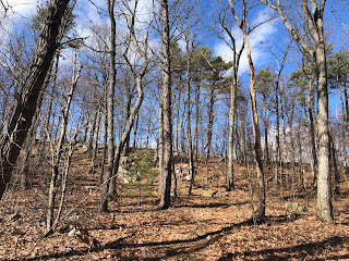
| Looking out over the Cumberland Valley from Rock Scree Trail |
Beginning at the bottom of the hill, at the Pine Plantation
parking area, and ending at the mansion at the top, I find rock scree to be of
the most challenging of the trails in the park. Whereas Kings Gap Road takes a
circuitous 4-miles route to the mansion, this trail is more direct, and the
elevation climb more substantial. It is just a little under two miles but
challenging. And once at the top, there is always the return trip to be made,
at least it is downhill from there. Still, it is one of my favorite trails because
of the change in scenery and the challenge.
Pine trees are among my favorites. The tall straight loblolly
pines in the Pine Plantation recreation area are inspiring. On a windy day,
such as this, the whooshing sound of air going through the pine needles is
amazing. Yet, many trees not doing well in this area. The number of dead and
downed trees is disturbing. I had to step over four downed trees at the
beginning of the walk. From the road it is apparent that many trees had been
feasted on by woodpeckers, doubtlessly ravished some infestation.
Despite being 50 degrees there is still some ice on small
ponds and, consequently, some very muddy stretches. But it is the first time I
have been on the trails at Kings Gap this year. Some snow is still on the
ground and trail on north side of the hills. My hike, on the second Saturday of
February, coincides with the birthday of Abraham Lincoln, who gave his most
famous speech just thirty miles away in Gettysburg. Earlier in the week, it was the birthday of
Charles Dickens, who would often walk twelve miles a day. The day before, it
was the birthday of Patrick Leigh Fermor, one of the best travel writers and
who at eighteen began his walk across Europe in December 1933.
 |
| The Rock Scree |
The rocky path is tricky on good days, but a layer of dead
leaves hides rocks on which twisted ankles might occur. A scree, not a
particularly common word I think, is a collection of rocks that have fallen
from a higher elevation. A source notes that is comes from the old Norse word skritha,
meaning landslide. Just as I work my way
through the scree, I meet an older gentleman carrying an empty plastic root beer
bottle walking with an adolescent who never made eye contact with me. I took
the opportunity to move to the side of the path to let them pass, ostensibly to
be polite but actually needing a rest. The kindly man sheepishly said, “Picking
up trash… I hate when people do that…” I agreed with his sentiment, but
breathing heavily I just got out, “I know.” He continued, shaking his head, “So
disrespectful. Have a nice day!” I bade him a good day as well, recovered a
bit, and continued. The worse of the climb was over.
Near the top of the trail, close to the intersection of Forest
Heritage Trail, one of my old friends stands in silent vigil. It is a tall,
mature Black Gum tree, with most of its trunk rotted away. I know that it can
survive like this for years, but it has a terminal condition. You can see
through it, and the gap in its wood on the inside goes up a further three feet
from what is seen from the trail. It is susceptible to wind, and it is not
getting the optimal amount of nutrients from its roots. I like to walk by and
check on it when I am hiking in the area. Typically, I give it a pat as I go by
as an acknowledgment.
 |
| An old friend |
 |
| Kings Gap Road |
I returned for a third successive weekend to Kings Gap.
This time on a Saturday, rather than Friday afternoons. The snow and ice from a
storm a few weeks ago have made trails and sidewalks impassable. Since then, it
has been cold with very little melting. Kings Gap, a favorite, if relatively
inconvenient, place to walk beckons. One of my goals this year is to complete
the Kings Gap challenge, successfully hiking every trail through the park. I
came close last year but had a couple of trails left, not getting myself
organized in time. Even at Kings Gap, however, the trails are icy and
dangerous. The prospect of falling on the ice, breaking a bone, or straining my
back, without good cellular service is just not something I want to chance.
Instead, walking the four-mile-long Kings Gap Road, from
the park entrance to the lodge at the top of the mountain is a good substitute.
The occasional automobile does not spoil the tranquility of walking in the
woods. It also provides additional safety; if I were to fall chances are much
better than someone would be along sometime soon to give me a hand. The first
two times I parked at Black Gum Parking Area and walked to the top. On my third
visit, I parked near the entrance. Normally I would start at Pine Plantation,
but the parking lot was covered in ice. The previous two nights, nearly two
inches of rain fell, and then the temperature dropped quickly. I pulled into
the parking area, which was a sheet of ice, to use the restroom before starting
and nearly fell a couple of times. It made more sense to park elsewhere, but
the ice was so slick it was not easy to get the car up the small incline to get
out. I parked, instead, at the small parking lot at the nearby Nature
Conservancy Preserve and walked toward the top of the mountain one the cleared
road.
Kings Gap is quiet during the winter, except for the wind
blowing through the dead leaves still clinging to the trees and the occasional
trail runners yelling their conversations back and forth to one another as them
make their way up or down the trails and roads. A few birds can be heard but
often not seen. The snow creates beautiful vistas and muffles distance sounds.
 |
| Water tower and loblolly pine at the top of the mountain |
As I was walking back down, lost in my thoughts, and enjoying nature, my left foot hit a piece of “black ice,” melted snow that has recently refroze but looks like wet asphalt. I could not pick up my foot, it kept sliding in slow motion. Soon I was close to do the splits when my right knee touched the ground and stopped the slide. It was a reminder that I should pay attention and not be so cavalier during the winter. I suffered no injury, just chastened.
Nearing the car, I heard the distinct sound of pileated
woodpeckers, one of my favorite birds. Then, I followed the sound and saw two
flying between trees. It was the first good look at a bird on the walk. I
immediately spook one, but the other went to a nearby tree and began scrounging
for food in the bark. I got closer, took a couple of photos, and was prepared
to wait for it to be in a better position. I crept closer, then a car came barreling
down the road, with two Weimaraners hanging their head out the back windows
voicing their pleasure. The woodpecker flew away in haste, far enough I lost
track. I would have to wait another day for that good picture of a pileated
woodpecker.
 |
| A pileated woodpecker, before getting scared |
On the way:
 |
| An abandoned house on Walnut Bottom Road (PA 174) between the villages of Walnut Bottom and Centerville, near the intersection of Quarry Hill Road. |